• Skip to primary navigation
  • Skip to main content
  • Skip to primary sidebar
  • Skip to footer

News and entertainment worth sharing – York and North Yorkshire

  • News
  • Radio
  • Vouchers
  • WIN
  • More
    • Tickets
    • Lifestyle
    • Advertise
    • About
    • Contact

As it happened – Flooding updates for York and North Yorkshire, 22 January 2021

York live

Friday, 22 January, 2021

Updates as rivers peak in York and North Yorkshire. Got info? Let us know on Twitter, or at [email protected]

All the latest flood warnings are here

• Key updates

  • Some Norton residents told to move items upstairs ‘and prepare for flooding’

    4 years ago

  • Malton’s fight against the floods isn’t over yet

    4 years ago

  • The work goes on in Malton and Norton after record high river levels

    4 years ago

  • Here are the roads still closed in North Yorkshire

    4 years ago

  • 17 pix: York’s floods on Friday – as river levels fall

    4 years ago

  • ‘We’re preparing for more rain’ – Environment Secretary

    4 years ago

Refresh for latest updates

Some Norton residents told to move items upstairs ‘and prepare for flooding’

4 years ago

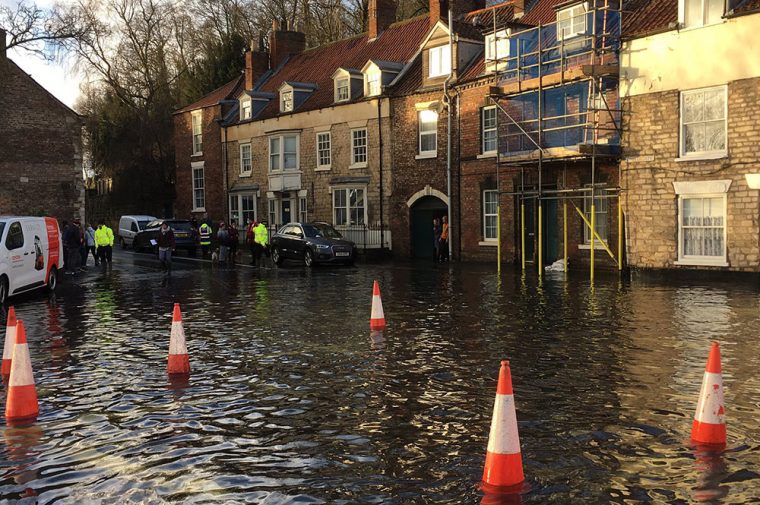
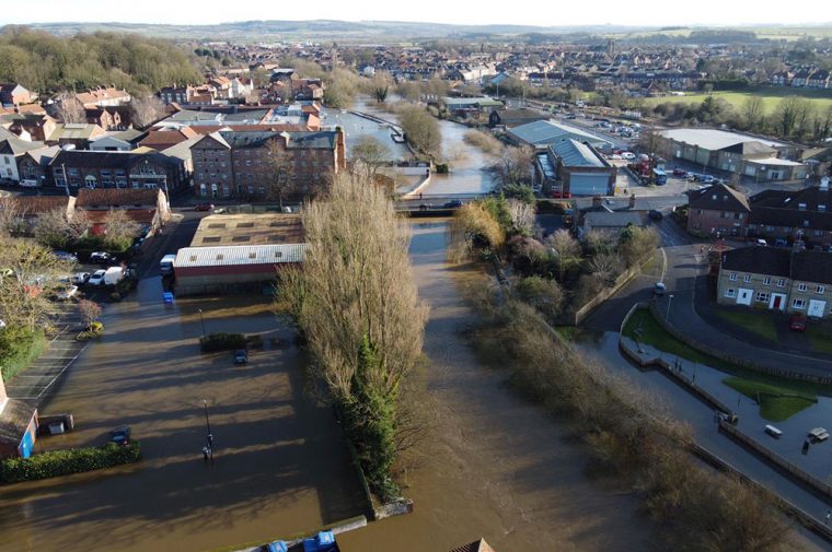
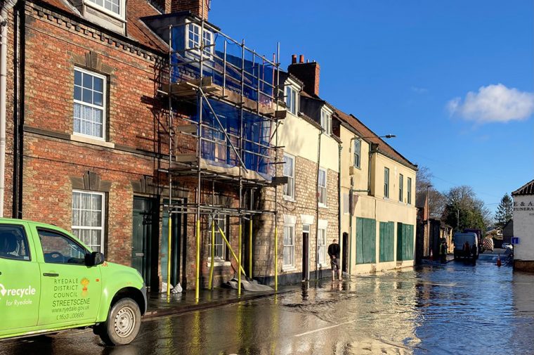
An aerial view of the floods in Malton – ‘sent to me by a friend,’ says Cllr Nathan Garbutt-Moore on Twitter

“Worryingly in a developing situation residents have been told to move items upstairs and prepare for flooding in Norton,” says Cllr Nathan Garbutt-Moore on Twitter.

Replying to the vice-chairman of Ryedale District Council, one resident writes to say: “Our street is now in the red area and we’ve had the automated call to say we need to prepare but we have no idea what has brought this on.”

Cllr Garbutt-More said: “Also trying to find out what the developments are, it did and was expected to start dropping after the peak this morning… it’s very different to the briefing I had earlier today.”
https://twitter.com/Ngarbuttmoore/status/1352700137492144133

This amazing drone footage shows the floodwater near Selby

4 years ago

Freelance video producer Alex Brown has shared this remarkable drone footage he shot, showing the extent of the floodwater at Kelfield.

Some drone footage I took of the flooded River Ouse near Kelfield today. #yorkfloods @daviddunninguk pic.twitter.com/o7ApLaJb5V

— Alex Brown (@alexbrownvideo) January 22, 2021

Malton’s fight against the floods isn’t over yet

4 years ago

The battle to save Malton and Norton from the floods goes on tonight.

An updated flood warning has been issued, as the Derwent continues to rise. It has now reached 5.16m.

Leader of Ryedale District Council Keane Duncan said: ““The area covered by this latest warning is significantly larger than the initial warning around Welham Road. It includes the railway station, St Nicholas Street, Church Street and parts of Scarborough Road.”

The full story is here:

https://yorkmix.wpengine.com/updated-flood-warning-issued-for-malton-and-norton/

More pictures from Malton

4 years ago

The scene in Malton today. Photograph: Ken Monkman on Twitter

Thanks to Ken Monkman for these pictures of Malton today, which he shared on Twitter.

“Sunshine today but Malton counting the cost of the floods,” he said.

Photographs: Ken Monkman on Twitter

The work goes on in Malton and Norton after record high river levels

4 years ago

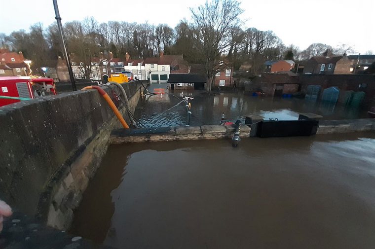
The pumps in action in Malton. Photograph: North Yorkshire CC on Twitter

Many agencies are involved in the work to tackle the floodwater in Malton.

Nine emergency pumps are being used to pump the water safely back into the Derwent.

It rose to a record high of 5.05m – but the flood defences held.

Agencies have been working through the night to protect residents and properties.

Cllr Keane Duncan, leader of Ryedale District Council, said: “The river looks to have peaked at 5.05m earlier this morning.

“This is a new record high, but we can’t compare 2000 with 2021 as we now have the defences to protect the towns.

“The situation is under control at the moment with no major property flooding.

“We have a tried and tested plan, and we are putting that into place.

“Teams from the councils, fire and rescue and Environment Agency remain on the ground. Well done to all of them.

“Extra pumps have been drafted in overnight and this morning.

“There is more water in and around St Nicholas Street too and it is very icy under foot. County Bridge is not accessible to pedestrians, with Norton Road difficult to traverse due to pumps.

“Please stay safe out there if you do need to venture out.”

There is a large multiagency response, including ourselves, @NYorksPolice, @NorthYorksFire, @RyedaleDC and @EnvAgencyYNE taking place in #Malton to pump water safely into the #RiverDerwent. pic.twitter.com/V2vuPyplG5

— North Yorkshire Council (@northyorksc) January 22, 2021

We've got teams out and about to help check on people affected by the flooding. They're checking people are OK, offering reassurance and support where needed. The community spirit shown by citizens and the partnership working is something Ryedale can be proud of. pic.twitter.com/TrTUzJxOfu

— Ryedale DC (@RyedaleDC) January 22, 2021

Here are the roads still closed in North Yorkshire

4 years ago

This is the latest list of roads closed – by both snow in the north and flooding elsewhere – in North Yorkshire.

And there are some roads which are tricky but passable with care.

Closed:

  • Askrigg East and West Moor – closed due to snow
  • Redmire Moor – closed due to snow
  • Kirby Wiske – Maunby
  • Dalton lane at Cod beck Blenders
  • Cowlands Lane, Holme-on-Swale
  • Water End, Brompton
  • Blakey Lane, Thirsk
  • C31 at Yoredale vets
  • Howe Village
  • Cowland Lane, Holme on Swale
  • Deighton Lane – between Brompton and Deighton
  • C100 Tollerton Lane (Mosy Bridge)
  • C100, York Bridge, Tollerton
  • Willow Beck Lane, between Romanby and Yafforth Road (underneath railway overbridge)
  • Firby Road, Bedale
  • Appleton Wiske, near primary school on road to Deighton.
  • Catton Lane Topcliffe ( at Topcliffe Mill)
  • The Carrs at Ruswarp
  • Castlegate, Norton Road (Blackboards)
  • County Bridge in Malton
  • Church Street in Norton
  • Pale Lane, Carleton
  • Winterburn Lane, Wiinterburn, Abbey Hill Junction
  • A65 Settle to Long Preston
  • B6106 Linton to Threshfield (Disused Rail Bridge)
  • Heslaker Lane, Carleton
  • Bentham Road, Ingleton
  • Thornton Bridge
  • Spofforth Lane, North Deighton
  • Occaney Lane to Copgrove Hall
  • Skip Bridge layby
  • C289, Oxton Lane and The Rampart, Bolton Percy
  • Mill Lane, A162 to Stutton at Cock Beck
  • Kirby Wharfe village street
  • B1223, New Road, Ulleskelf
  • B1223 Boggart Lane, Ullleskelf to Ozendyke
  • B1223 The Fleet, Ryther
  • B1222, Cawood Bridge
  • B1222, Stillingfleet to Moreby Hall
  • C310, Mount Pleasant to Kelfield
  • C314, Station Road, Wistow
  • A163, North Duffield to Bubwith
  • C327, Newton Lane, Fairburn
  • C331, Intake Lane,Birkin to Beal
  • C329. Birkin to Byram – flooded
  • Marsh Croft, Brotherton – flooded
  • Stocking Lane, Kellingley – flooded
  • Walden Stubbs village street – flooded

Passable with care:

  • C28 Melsonby to Aldbrough St John
  • Harforth Lane near Gilling West
  • C43 Semer Water
  • U1379 Dalton Gates
  • A6136 Ash House at Brough St Giles
  • A170, Sutton-under-Whitestonecliffe
  • Bullamoor Road: beyond the Fox & Hounds pub, towards the A19
  • B6267, near Howe
  • B6285, Floodbridge
  • C36, Well to Thorpe Perrow
  • Station Road, Hutton Rudby
  • C99, Dalton village
  • C168, Willowbridge Lane/Islebeck Lane
  • C149, Kirby Sigston at Sigston Castle and Sigston Bridge
  • Tanton Road, Stokesley
  • Leeming – Mill Lane
  • C1 between A173 to Kildale
  • Easby Lane Great Ayton.
  • Quarry Lane Osmotherly (sheep wash)
  • Faceby to Carlton in Cleveland
  • Middlerton Road, Hutton Rudby
  • Crathorne Village, Crathorne
  • Angram Road, Long Marston
  • Castle Lane
  • Denton
  • Pateley Bridge
  • Summerbridge
  • Hampsthwaite
  • Sections of B6265
  • Between Darley and Birstwith, New Row
  • Tockwith Road – Long Marston 
  • A59 Harrogate to York approach to Whixley cross roads
  • A645/Broach Lane junction and Low Road/Lunn Lane, Kellington

17 pix: York’s floods on Friday – as river levels fall

4 years ago

Tower Gardens, with Clifford's Tower behind, in the floods of January 2021. Photographs: Richard McDougall

Our photographer Richard McDougall has been out and about in the city this morning, capturing the latest on the floods.

Levels of both rivers are falling. At 11.30am, the Ouse was at 4.55m – down from 4.6m at four hours earlier.

It is predicted to stay around this level until it starts dropping in the early hours of tomorrow (Saturday), reaching 4.26m at 11am.

The River Foss, meanwhile, has dropped to 1.80m at 11.45am, down from 1.98m at 7.45am.

It is receding fast, and Huntington Road reopened this morning.

Here are the latest road closures:

  • Clementhorpe – closed at Terry Avenue
  • Fordlands Road – closed, scaffold walkway in place to allow pedestrian access for essential travel
  • Knavesmire Road – closed
  • Main Street, Nether Poppleton – closed
  • Millennium Bridge – closed
  • Naburn Lane, Naburn – closed
  • Naburn Village – closed
  • Skeldergate – closed, access to City Mills sheltered housing via City Mills bridge.

St George’s Field car park, Esplanade car parks and Rowntree Park and car park are also closed, due to high river levels.

The floods in pictures

Here’s the Ouse today

4 years ago

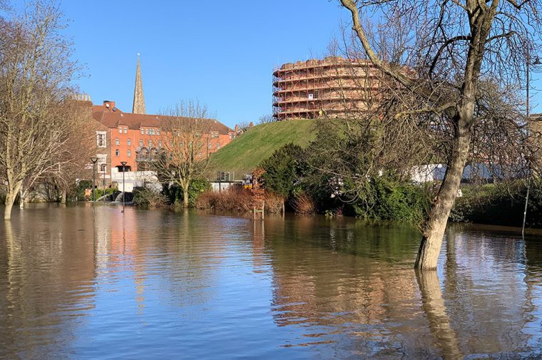
Photograph: Phil Prosser

Two great images of the river in York today. Thanks to Phil Prosser and Lauren Leach.

What a relief to see the blue skies!

Photograph: Lauren Leach

‘We’re preparing for more rain’ – Environment Secretary

4 years ago

Storm Christoph is now set to give way to colder winter weather this weekend as rainfall begins to ease, according to the Met Office.

But Environment Secretary George Eustice said authorities are monitoring river levels in Yorkshire and preparing for more rain expected next week.

He said flooded properties are a “real tragedy” for anyone affected, with around 70 homes deluged in the recent adverse weather.

York weather forecast

He told BBC Breakfast: “It is incredibly disruptive when people have their homes flooded, but around 26,000 homes have been protected from the various flood defence assets we have had in place.

“We have got 600 people on the ground putting up temporary barriers, using pumps in areas of Manchester where there were particular flood challenges.

“We are particularly monitoring the situation in Yorkshire as the water moves through those river systems and, of course, preparing as well for next week where later next week more rain is expected.”

He said around £2.5 billion has been spent on flood defences over the last five years.

Here’s what the Derwent looks like at Stamford Bridge

4 years ago

The Derwent at Stamford Bridge. Photograph: Jay Commins on Twitter

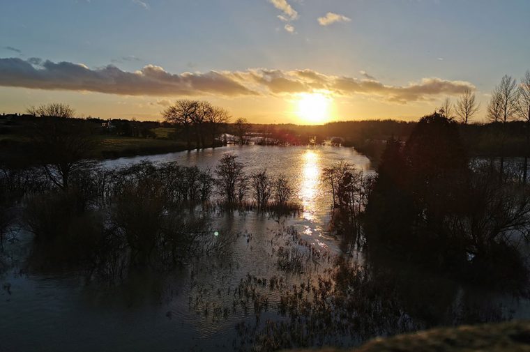
Jay Commins has tweeted out these atmospheric photos of the Derwent in flood at Stamford Bridge.

The Derwent in flood in #StamfordBridge pic.twitter.com/LdoY50oscm

— Jay Commins (@JayCsaid) January 21, 2021

Huntington Road reopens

4 years ago

York Travel tweets that Huntington Road, which was closed at the iron bridge due to floodwater, has reopened.

Huntington Road is now open.

— York Travel (@york_travel) January 22, 2021

Here’s a reminder of what it was like yesterday:

The struggle to save Malton

4 years ago

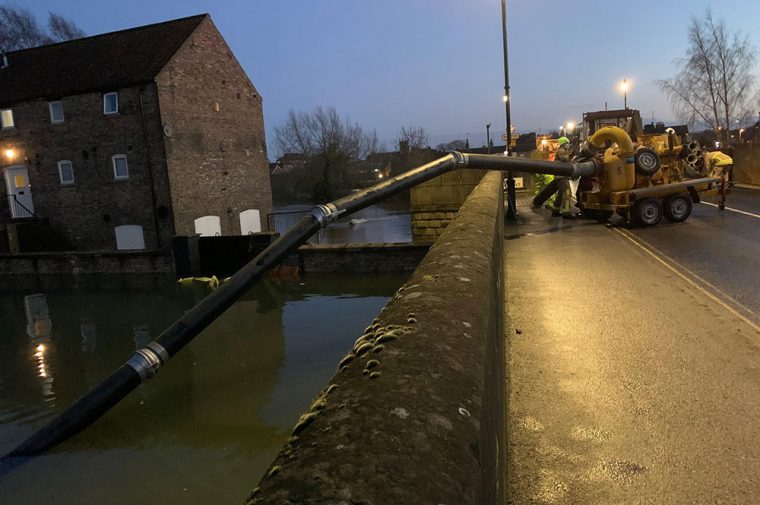
This picture from Thursday night shows a pump added on the County Bridge in Malton. Photograph: Martin Dales

This picture shows the extraordinary efforts to keep the floodwaters at bay in Malton.

Town councillor Martin Dales took the picture last night (Thursday). It shows “A serious pump being added to the other eight already in the County Bridge area,” he said.

As we reported earlier, these efforts appeared to have worked as the Derwent has peaked without a breach.

Today, though, roads in the town remain closed.

County Bridge remains shut, and there are road closures in place at

  • Castlegate
  • Norton Road (Blackboards)
  • and Church Street.

Latest flood warnings

4 years ago

Flood warnings near York

  • River Derwent at Stamford Bridge – The Weir Caravan Park and Kexby Bridge
  • River Foss at Layerthorpe to Foss Islands Road, Stonebow and Piccadilly
  • River Foss downstream of Yearsley Baths – riverside properties
  • River Foss upstream of Yearsley Baths
  • River Foss upstream of Yearsley Baths to Strensall – riverside properties only
  • River Ouse at Acaster Malbis
  • River Ouse at Bishopthorpe
  • River Ouse at Naburn Lock
  • River Ouse at York – Clifton
  • River Ouse at York – Fulford and Fordlands Road
  • River Ouse at York – riverside properties
  • River Ouse at York – Skeldergate and Tower Street
  • River Ouse at York – St George’s Field and Queen’s Staith

Flood warnings near Malton

  • Mill Beck at Welham Road, Norton
  • River Derwent at Old Malton

Flood warning at Selby

  • River Ouse at Selby Dam

York in flood this morning

4 years ago

Here are some of your images.

#York is #flooded again. Here fingers of #light sit on the #RiverOuse by #OuseBridge. Pretty dramatic stuff and the highest that I’ve seen the #River #Ouse for a long time.
#YorkNews #photojournalism #flood #floodwater #nature #naturaldisaster #StormC… https://t.co/DiIhJMhopI pic.twitter.com/tpGLRVSIJa

— Moss Travel Media (@mosstraveltv) January 22, 2021

#York is #flooded again. Here the #RiverOuse is above #DameJudiDenchWalk and the #gardens of #EarlsboroughTerrace. Pretty dramatic stuff and the highest that I’ve seen the #River #Ouse for a long time.
#YorkNews #photojournalism #flood #floodwater #na… https://t.co/hqXaDQaTsN pic.twitter.com/Rwbdp57501

— Moss Travel Media (@mosstraveltv) January 22, 2021

Hard to believe this shows the top of the wooden pagoda walk and maze area in Rowntree Park 😮 The water must be 7' deep 😬#StormChristoph #rowntreepark#floods #york @Fr_RowntreePark#flooding @EnvAgencyYNE @yorkpress pic.twitter.com/Rv1aHwsbVL

— York360 (@York360) January 22, 2021

River Ouse #York in flood over night #river #Ouse pic.twitter.com/Z2hiRysThL

— Water Towers (@watertowers) January 22, 2021

Few more from the walk today @theyorkmix @YorkBID #floods #york pic.twitter.com/eTAuVt0rEg

— Tracey Sharp (@TraceySS66) January 22, 2021

Boat sinks on the Ouse near York

4 years ago

Photograph © Google Street View

A boat sank in the River Ouse early this morning.

Firefighters were called out shortly after midnight to the river at Bishopthorpe, opposite the Naburn Sewage Works.

A pleasure craft had sunk still secured to a floating platform. But other boat owners were concerned it would break free.

Using the Fire Rescue Boat, a crew inspected the boat.

A North Yorkshire Fire & Rescue Service spokesperson said: “Crews attended an incident involving a boat that had sunk whilst still secured to a floating platform.

“The boat was in a safe and stable condition, crews carried out an inspection only and gave advice to neighbouring boats to monitor the situation overnight.”

Selby flood warning in force

4 years ago

Here’s the latest flood warning for the River Ouse at Selby Dam, issued at 3.50am today: “This Flood Warning has been issued in response to rising levels on Selby Dam due to recent rainfall. The areas most at risk are around Leeds Road in Selby.

“We have teams on site at Selby Dam Pumping Station, and are monitoring the situation closely. No further significant rainfall is forecast for the next 24 hours. Please avoid using low lying footpaths near local watercourses and do not drive through flood water.”

It had reached 3.93m at 8:30am.

Malton has a ‘near miss’

4 years ago

Malton today. Photograph: Alex Hornby on Twitter

The River Derwent in York is about to peak at just over 5m above normal levels.

The Environment Agency told BBC Radio York the flood defences should hold, although it will be a “big test” for them.

The River Derwent mercifully peaked at Malton and Norton at 0530. Diversions remain (see @yorkbus) and our thanks go to all our #Coastliner and York colleagues for keeping our customers on the move during the floods in both locations. 👏👏👏👏 pic.twitter.com/9lfYDYAdC4

— Alex Hornby (@alexhornbybus) January 22, 2021

Today’s York river levels and forecasts

4 years ago

The good news we heard yesterday seems to be holding in York.

Today the River Ouse in the city has reached 4.6m and is predicted to rise to 4.71m – which means the temporary flood defences should hold.

For the Foss, there’s even better news. By 7.45am it had fallen to 1.98m and is set to continue to fall.

Footer

Contact us

General
01904 375 029

Studio/competitions
01904 375 030

Email YorkMix »

5-6 King's Court
Shambles
York  YO1 7LD

Listen to us

You can listen to YorkMix Radio using your DAB+ radio, Alexa or Google smart speaker, or online using the links below.

Click here to listen to YorkMix Radio »

Download the app from Google Play store
Download the app from Apple App store
About us

YorkMix is a trading name of
York Sound Ltd

Registered in England
Company no: 12831940
VAT no: GB289462452

YorkMix Radio public file

  • About
  • Public file
  • Privacy policy
  • Corrections & complaints
  • Contact

Copyright © 2025 YorkMix