
After two storms in three days, the weather conditions are continuing to cause problems in York and North Yorkshire.
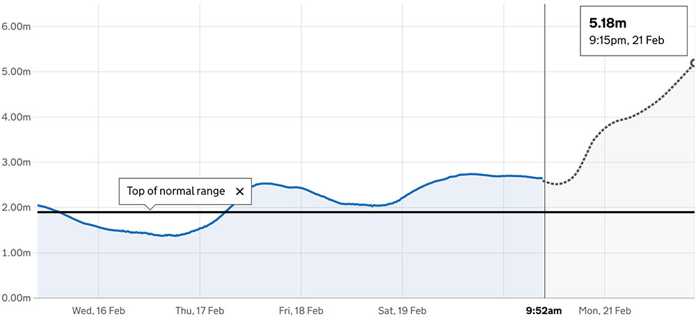
Five flood alerts are in place around York. The latest forecast for river levels in York city centre see them reaching 5.18m at 9.15pm tomorrow.
That’s close to the record levels recorded by the Viking Recorder, of 5.40m on 4 November 2020.
Strong winds and heavy rain showers are forecast for today, with some lighter showers to follow on Monday and Tuesday.
Today (Sunday), roads are being hit by localised flooding. Police said roads in the Harrogate and Craven areas were seeing flooding on the following routes:
- A65
- A59
- B6265
- B6479
Police tweeted: “Don’t drive into flood water that’s moving or more than 10cm (4 inches) deep. Let approaching cars pass first. Drive slowly and steadily.”
These are the flood alerts in force in and around York:
Upper River Ouse
Flooding is expected to affect locations near the River Ouse, with low lying land most affected, particularly around Riverside footpaths and low-lying land in York and south as far as Naburn Lock, including Kings Staith, Queens Staith, and South Esplanade.
Tidal River Ouse from Naburn Lock to Selby
The current river level at Naburn is 2.65m. The current river level in York is 2.33m. Low lying land around the River Ouse is at risk of flooding. Levels are forecast to fall slowly during the day on Sunday. Further significant rain is forecast for Sunday, which is expected to cause levels to rise again from Sunday evening until Tuesday morning.
Lower River Derwent
Flooding is forecast to affect locations near the River Derwent, with low lying land expected to be most affected, particularly around local roads and low-lying land around Stamford Bridge, Pocklington, Wressle, Wilberfoss and Elvington this morning, Sunday.
[tptn_list limit=3 daily=1 hour_range=1]
Lower River Nidd catchment
Flooding is forecast to affect locations near the River Nidd, with low lying land expected to be most affected, particularly around Land around the Lower River Nidd and its tributaries including Sand Beck, Sike Beck, Pool Beck and Great Gutter.
Lower River Wharfe
Flooding is forecast to affect locations near the River Wharfe, with low lying land expected to be most affected, particularly around The Lower River Wharfe and tributaries from Ilkley to upstream of Ulleskelf.
For all the latest flood alerts and warnings go here.