• Skip to primary navigation
  • Skip to main content
  • Skip to primary sidebar
  • Skip to footer

News and entertainment worth sharing – York and North Yorkshire

  • News
  • Radio
  • Vouchers
  • WIN
  • More
    • Tickets
    • Lifestyle
    • Advertise
    • About
    • Contact

As it happened – Flooding updates for York and North Yorkshire, 21 January 2021

York live

Thursday, 21 January, 2021

Updates as Storm Christoph causes flooding in York and North Yorkshire. Got info? Let us know on Twitter, or at [email protected]

All the latest flood warnings are here

• Key updates

  • The Foss and Ouse: Latest levels and forecasts

    4 years ago

  • Video: Floodwater on Huntington Road

    4 years ago

  • York flood briefing: Foss – no homes inundated yet; Ouse – defences holding up

    4 years ago

  • Here are all the roads affected by floods in North Yorkshire

    4 years ago

  • Malton flooding latest – River levels ‘very high’, roads closed

    4 years ago

  • Here are the latest River Foss levels as it reaches its peak

    4 years ago

Refresh for latest updates

Man rescued after five hours stuck in van in floodwater

4 years ago

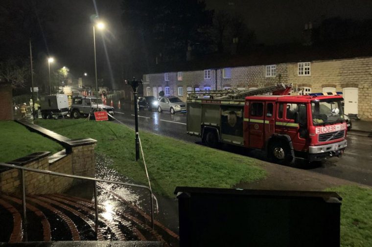
Firefighters have rescued a man who had driven into floodwaters at Buttercrambe.

He had sat in his van for more than five hours before calling for assistance.

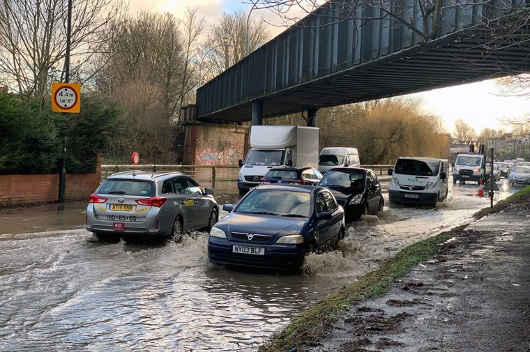
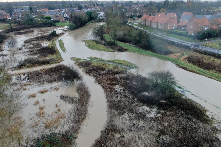
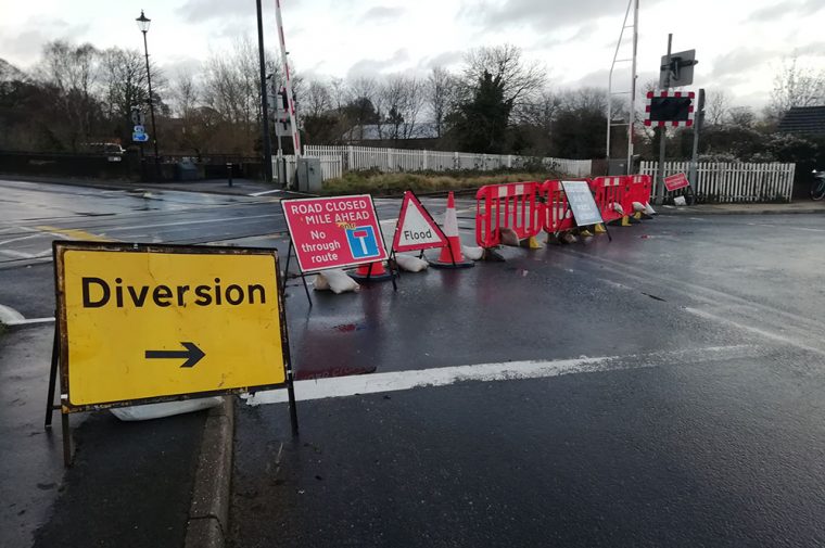
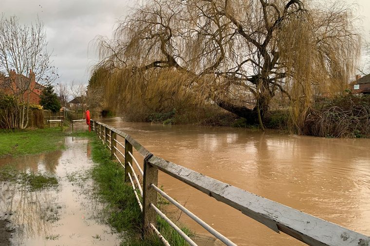
Meanwhile Ryedale District Council sent out this message: “Please respect road closures and do NOT try to go through flood waters tonight.

“Our colleagues at North Yorkshire Fire have told us of people trying to cycle, drive and walk through flooding in Norton and Malton earlier today. Don’t put yourself in danger and stay out of flood water.”

I have just attended an incident with #Malton & #Pickering at #Buttercrambe rescuing a 58 year old male who had driven into flood water. He sat in his van for over 5 hours before calling @NorthYorksFire for assistance.

Please don’t drive around road closed signs@theyorkmix pic.twitter.com/tkfAaH9IKR

— Group Manager Bob Hoskins (@Golf_One4) January 21, 2021

Residents in 130 homes in York given the chance to evacuate

4 years ago

This from Chloe, the Local Democracy Report for York.

⚠️ The council has offered evacuation to about 130 homes near the River Ouse in York this evening, in Clementhorpe & Peckitt St

Residents have the option of a covid-safe hotel room, creating a new 'bubble' with family or friends, or staying home

River set to peak at 4.7-4.8m

— Chloe Laversuch (@ChloeLaversuch) January 21, 2021

The Foss and Ouse: Latest levels and forecasts

4 years ago

The latest update from the Environment Agency at 5.15pm puts the River Ouse in York city centre at 4.55m.

It is forecasting the river will peak at 4.73m at 5.45am tomorrow (Friday, 22 January). That’s well above the level where some flooding in properties is possible.

But it is also well short of the 5.2m-5.4m which would cause serious problems.

The graph for the River Ouse Viking Recorder

Meanwhile, an update of the River Foss issued at 5.15pm shows the latest level at 2.73m.

The graph for the River Foss at Huntington

Updates from Selby

4 years ago

A number of roads in our district are closed due to flooding (incl Cawood bridge). Please avoid the Station Road area in Wistow where there is a lot of water in the road. Never drive through flood water. Keep up to date with road closures here: https://t.co/wkfApRFOhw pic.twitter.com/5sIRAxwsHV

— Selby DC (@SelbyDC) January 21, 2021

Road out of Kelfield to Cawood well underwater. pic.twitter.com/rc2Qh5tSsO

— Alex Brown (@alexbrownvideo) January 21, 2021

#Selby crew are currently pumping water away from properties in Bortherton. 1 major pump in use and will soon be joined with the council and their pumping capabilities. @theyorkmix @Selby_Times pic.twitter.com/912VuARtDu

— Tony Walker (@sierra18NY) January 21, 2021

Here’s the latest from Malton

4 years ago

Latest photos just now from flooding in Malton and Norton – roads still closed around County Bridge, with emergency services working on site and extra pumps brought in @BBCYork @KarenGazette @gazetteherald @yorkpress @TheScarboroNews @ThisCoast @theyorkmix @daviddunninguk pic.twitter.com/PSGB4gQ6RR

— John Gelson 💙🚍🇺🇦 (@JohnGelson) January 21, 2021

Plea to stay off Rawcliffe Ings – as questions are asked about sluice gate

4 years ago

If you’re thinking of going for your daily exercise on Rawcliffe Ings, please don’t. That’s the message from York Rescue Boat this evening.

It comes as questions are asked about why the sluice gate there hasn’t been opened.

David Sempers contacted the York Press with this observation: “It just looks like a big, long waterfall.

“There’s a metal sluice gate at the Skelton end of Clifton Ings. Normally they open that to let water into the Ings, then when the Ings are full they close it. When the river level goes down again there’s another gate at the Clifton Bridge end. They open this to let the water out.

“If they aren’t opening the gate to let water into the Ings it means there will be more water downstream. I just can’t understand why they haven’t done it.”

Please stay off Rawcliffe Ings and the associated flood embankments, we are already seeing overtopping from the River Ouse into the flood water holding area. Photo taken under the A1237 bridge.@EnvAgencyYNE @CityofYork @YorkMix @yorkpress @BBCYork pic.twitter.com/z4Lr2435qc

— York Rescue Boat (@yorkrescueboat) January 21, 2021

Video: Floodwater on Huntington Road

4 years ago

Cars going through the floodwater on Huntington Road. Photograph: YorkMix

This is the floodwater which is now across Huntington Road.

It’s under the bridge close to Ramsay Close.

Cars can get through at the moment with care. The Foss is thought to be at or near its peak, so it’s hoped that the conditions won’t deteriorate further.

Video: Water pouring over the flood bank at Kelfield Ings

4 years ago

Here’s an update from Cawood in the Selby district, from Alex Brown.

Water currently pouring over the flood bank into Kelfield Ings. #StormChristoph #Christoph @daviddunninguk @theyorkmix #yorkfloods pic.twitter.com/8bh8oGcC90

— Alex Brown (@alexbrownvideo) January 21, 2021

Water overtopping the Rawcliffe flood bank

4 years ago

Water overtopping Rawcliffe flood bank today. Photograph: Louise Sharp

Here’s an update from York councillor Darryl Smalley.

“A council engineer has been out to Clifton/Rawcliffe Ings. They have reported that whilst the water is overtopping, it is not causing much damage to the embankment.

“They will continue to monitor it. The gate was opened this morning to maximise the use of the Ings storage area.

“If the embankment is being damaged due to overtopping, it will not increase flood risk to any properties. It has been damaged in the past and the council will go in after the levels reduce to carry out repair work.”

River Ouse levels are expected to rise quickly to about 4.7m tonight, he said.

As posted earlier, a Facebook Live Q&A on the floods is taking place at 5pm tonight. The panel will be discussing flooding preparations, what to do when river levels rise and how to stay safe.

There’s more on www.york.gov.uk/floods.

Reader Louise Sharp, who sent the picture above of the Ouse overtopping Rawcliffe flood bank, said: “Rawcliffe residents have been assured that should the bank give way properties are not at risk.”

Situation ‘easing’ in Old Malton

4 years ago

Work to prevent flooding in Old Malton

Malton Town Council’s Martin Dales sends us this update: “Last night there was rapid increase in flooding in Old Malton.

“There were and still are seven pumps working hard to move water over the flood defences into the River Derwent.

“A multi-agency response including Malton’s North Yorkshire Fire & Rescue ensured pumps were in place and properties threatened sandbagged with the seventh one arriving, fitted and working by 2.30am today.

“Grateful thanks to the 20+ front-line staff involved as well as all those working in support in the background.

“The situation today is far better now and homes and businesses are not under threat. However, with County Bridge currently closed – the River Derwent is less than foot short of the level in pre-flood defences 1999 flood – a lot of traffic is being displaced onto the B1257 through Old Malton so do please drive carefully as work remains in progress.”

Fire crews back in the Tadcaster area today

4 years ago

This from North Yorkshire Fire & Rescue Service’s Bob Hoskins:

Crews from #Tadcaster @NYFRS_Tad are currently deployed at #KirbyWharfe assisting locals to prevent water entering properties
The @AquaDamEurope has been deployed by locals to hold back the rising water@theyorkmix @BBCYork @Selby_Times pic.twitter.com/mIq3Srlftp

— Group Manager Bob Hoskins (@Golf_One4) January 21, 2021

Pictures: Floodwater on Bridge Street, Tadcaster

4 years ago

The drains caused flooding in Bridge Street in Tadcaster last night.

The fire service arrived with pumps to protect properties that were at risk of flooding

Tadcaster Community Action Group published these pictures on Facebook.

Flooded fields behind St Peter’s

4 years ago

No chance of a game of football here. Photograph: Daniel James

These photos from Daniel James show fields behind St Peter’s School in York completely flooded.

Football and rugby pitches are inundated. But the water’s not going anywhere else.

Daniel said: “The flood bank here was strengthened in the autumn so all looks OK at the moment.”

Photograph: Daniel James

‘A fantastic job’

4 years ago

We’ve now posted a fuller version of the last update, with the latest news for York. It includes Cllr Paula Widdowson praising the council teams efforts:

  • We know how to work a flood now. We know what to put in place. Unfortunately, we’re very well practised at it. And it’s working like clockwork, they have done a fantastic job.

https://yorkmix.wpengine.com/york-floods-hopeful-signs-as-the-foss-peaks-and-the-ouse-defences-look-set-to-hold/

York flood briefing: Foss – no homes inundated yet; Ouse – defences holding up

4 years ago

Properties next to the Ouse this morning. Photograph: Richard McDougall

We have just come out of a media briefing organised by City of York Council on the latest position on the floods.

We’ll post a full story shortly, but here are some of the main points.

River Foss

  • CYC were alerted at 5.21am to the potential of properties flooding in the upper Foss basin
  • it is the intensity of the water flow, particularly around Strensall, that has caused the flash flooding there
  • the lower Foss basin is not affected and the Foss Barrier is working well
  • the Foss has reached 2.67m – around about the peak of what is being predicted this time
  • that affects about 100 properties in the Strensall to Yearsley Baths area, “but that’s principally gardens and outlying buildings with minimal levels of flooding expected within properties”
  • no in-property flooding has been reported as yet
  • “we don’t expect any further impacts on the Foss because that rainfall in the upper basin has obviously moved on”.

River Ouse

  • the Environment Agency expects the Ouse in York to peak at 4.76m at 3am tomorrow (Friday)
  • “that is within the flood plan for York in terms of our own defences of properties, so we’re not anticipating wide-scale flooding of properties at that level”
  • but it does require the temporary defences now in place
  • flooding at this level is set to affect just a handful of properties such as those at King’s Staith
  • if it went above 4.8 or 4.9m that would affect Peckitt Street
  • they are hopeful that the A19 near Germany Beck, Fulford, won’t be flooded
  • only when the Ouse gets “around about the 5.2 to 5.4 level, that’s when we become very concerned about the numbers [of flooded properties] jumping up exponentially”.

Hotels are on standby to take people impacted by the Foss flooding – but that evacuation plan is unlikely to be needed.

There was great praise for the City of York Council teams who have done all the defence work in Covid secure bubbles.

Drone picture shows extent of the Foss flood

4 years ago

The Foss from above around Strensall. Photograph: NYPolice Drones on Twitter

This picture was taken today by PC Paul Beckwith, chief pilot for North Yorkshire Police drone operations.

It shows the extent of the Foss flooding today around Strensall. The message – be careful, and don’t enter the floodwaters, “it is deeper than normal in a lot of places”.

https://twitter.com/NYPdrones/status/1352198231388729346

Question York council leaders about flooding

4 years ago

🎙️LIVE Q&A TONIGHT
With river levels expected to peak between 4.4 and 4.8m tonight our #AskTheLeaders session will focus on answering your questions about flooding.

E-mail your question in advance to [email protected] or ask them live on our facebook live steam. pic.twitter.com/Xjjp6zyeRr

— City of York Council (@CityofYork) January 21, 2021

Here’s how the Ouse is looking in York today – 11 pix

4 years ago

Clifton Bridge

Our team have been out and about checking out the rivers in the city this morning.

The River Ouse is very high, and still rising. And although the persistent rain stopped early on, York has since had another heavy shower.

Here’s what it’s looking like right now, courtesy of photographers Richard McDougall and David Dunning.

  • Cumberland Street
  • Tower Gardens
  • Tower Street
  • Skeldergate is closed
  • The swollen Ouse
  • From Clifton Bridge
  • Looking towards the ring road
  • The centre of town
  • Ominous clouds
  • Millennium Bridge

Disruption on the trains

4 years ago

The flooding is causing problems on some train routes, particularly those in the North West.

Northern services have been most affected, with a number of cancellations and diversions.

You can get live updates here.

Here are all the roads affected by floods in North Yorkshire

4 years ago

The list is from North Yorkshire County Council. It’s updated here.

RoadStatus
A19 between Chapel Haddlesey crossroads and Wand Lane, Eggboroughclosed
Footpath between St James Green and The Marage in Thirskclosed
Lead Lane from Blakey Ridge to Young Ralph’s Cross (Sugarloaf to Westerdale)closed
C32 Bruntacres (Hardraw Road)closed
A684 Appersettclosed
C34 between the A684 at Appersett and Hardraw Villageclosed
A684 Worton to Aysgarthclosed
C43 Semer Waterclosed
York Road Bridge, Tollertonclosed
Westerdaledale (near Castleton)closed
Heslaker Lane, Carleton (Carleton to Broughton)closed
Cattal villageclosed
Cattal Moor Lane from Tockwith crossroadsclosed
Ox Moor Lane from Hunsingoreclosed
B1223 The Fleet, Rytherflooded
Lunn Lane/ Low Road roadpartially flooded
The Rampart, Bolton Percyflooded
B1223, Button Hill, Cawood to Rytherflooded
A684 Wensley Bridgepassable with care
>C28 Melsonby to Aldbrough St Johnpassable with care
Kilgram Lane near Jervaulxpassable with care
A684 Stokesley Road Northallertonpassable with care
B1363 half a mile from Chop Gatepassable with care
Thimbleby Villagepassable with care
Girsby Villagepassable with care
Bentham Road, Ingleton junction with Bentham Moor Roadpassable with care
Masham bridgepassable with care
Kellington A645/ Broach Lane junctionpassable with care
County Bridge - B1248 between Malton and Nortonclosed

The B1222 at Naburn and Cawood Bridge are closed

4 years ago

The B1222 at Naburn and Cawood Bridge are closed. Buses are being diverted.

https://twitter.com/arrivayorkshire/status/1352177073809465345

‘It’s over the towpath and right up to the gate’

4 years ago

Carol by the River Foss. Photograph: David Dunning

Carol, whose home is right next to the iron bridge on the River Foss in York, is very concerned. It flooded in 2015 and there was lots of damage.

She was surveying the river this morning.

“It’s over the towpath and right up to the gate,” she told David Dunning on YorkMix Radio.

Carol got an alert from the Environment Agency at 5am this morning and is hoping the river doesn’t rise much further.

New pictures show the Foss is into people’s gardens

4 years ago

As these pictures show, the Foss is now flooding into the gardens of riverside properties in York.

The photos, taken by YorkMix‘s Richard McDougall, show the Foss beyond Yearsley Bridge.

Malton flooding latest – River levels ‘very high’, roads closed

4 years ago

Photograph: Ryan Swain

There are two flood warnings in Malton.

River Derwent at Old Malton – 6.57am update: “The current level of the River Derwent at Malton is 4.64m and will remain high. The level on the River Rye at Howe Bridge is 4.99m and will continue to rise slowly on Thursday. Pumps are continuing to operate in the area to manage groundwater and surface water.”

Mill Beck at Welham Road, Norton – 1.01am update: “Flooding of property, roads, and farmland is expected on Thursday morning. Areas most at risk are properties on Welham Road, Norton.”

The County Bridge has been closed, along with Norton Road. These photographs were taken this morning by YorkMix Radio presenter Ryan Swain.

https://twitter.com/Ngarbuttmoore/status/1352177469852442624

River levels in Malton very high. County Bridge has been closed to vehicles – including Blackboards – seems ok for pedestrians. Access to town from south is via Brambling Fields or Kirham. Very few spaces in Morrisons car park due to floods. Stay safe #Maltonfloods

— Si (@SimonHunter1929) January 21, 2021

Here are the latest River Foss levels as it reaches its peak

4 years ago

The River Foss at about 8.30am. Photographs: Richard McDougall

The River Foss was forecast to hits its peak about now. At 8am the river level York Castle Mills Sluices had hit 7.81m which is just at the point when it will overtop.

And at Huntington it was 2.62m, above the 2.2m level where minor flooding is possible.

The latest from the River Foss York Castle Mills Sluice
The latest from the River Foss at Huntington

City of York Council are going house to house to let property owners know the situation. They expect most of any flooding will be limited to outhouses and gardens, but “there may be water entering some properties in the Strensall to Yearsley Baths area and the low point near the iron bridge on Huntington Road”.

These York cycle routes are impassable

4 years ago

Here’s an update from the York Cycle Campaign. If a route is flooded turn round.

⚠️ Unsurprisingly the Is It Flooded page is showing all red, if you must travel allow extra time. Don't ride through flood water- they can hide debris and missing manhole covers.
@theyorkmix @BBCYork @yorkpress

https://t.co/5EFzEez3eA pic.twitter.com/YJkxoq4BcX

— York Cycle Campaign (@YorkCycle) January 21, 2021

Pictures and video: River Foss levels rise

4 years ago

YorkMix‘s David Dunning is out and about in York and he’s sent use these images and video from the River Foss.

As we reported earlier, there are flood warnings on the Foss today with possibly 95 properties affected. But no evacuations are needed at the moment.

The Foss Barrier is depoloyed.

The key roads affected in York

4 years ago

Flood defences going up in York. Photograph: Danny Lawson / PA Wire

This is the list of roads hit by flooding, from City of York Council.

Note: Anticipated times indicated – times will be affected by rate of rise of river level

Roads

  • Clementhorpe – closed at Terry Avenue junction.
  • Main Street Nether Poppleton – Closed
  • Naburn Lane – Closed
  • Fordlands Rd – Closed. A scaffold walk way is being put in place on the left hand side of the road entering Fordlands Road.
  • Skeldergate – Closed – Bus services will be diverted via Tower Street
  • Knavesmire Rd – Closed
  • Bishopthorpe Rd near Crematorium – one lane closed, route passable – observe traffic management
  • A19 Fulford – Defences in place.
  • Tower Street – Defences in place

Cycle/Pedestrian Routes

  • Riverside paths across city /Terry Avenue – Closed
  • Millennium bridge (pedestrians/cyclists) – Closed
  • City Mills bridge (access to City Mills Sheltered housing on Skeldergate) in place.

People should not drive, cycle or walk through flood water – it can contain hidden obstacles and health hazards. Residents are advised to check their route before travelling, if it is prone to flooding.

Here are all the bus diversions in York

4 years ago

One of First York's buses. Photograph: Richard Walker

Many roads are affected in York. This in turn is impacting bus services.

Here are all the diversions for First York services. You can see any updates on their website here.

Skeldergate (diverted from start of Service Thursday 21st January)

Service 3

Buses from Askham Bar will follow normal route to York City Centre, diverting from Micklegate via Ouse Bridge to Clifford Street.

Services to Askham Bar from Tower Street will observe normal route and stops.

Stops not served: None, customers who normally leave the bus at Tower Street, an alternative stop will be available on Clifford Street on the opposite side of the road (stop 32900168).

Additional stops served: None

Service 4

Buses from Acomb will follow normal route to York City Centre, diverting from Micklegate via Ouse Bridge to Clifford Street.

Service to Acomb from Clifford Street will observe normal route and stops.

Stops not served: None, customers who normally leave the bus at Clifford Street, an alternative stop will be available on Clifford Street on the opposute side of the road (stop 32900168).

Additional stops served: None.

Poppleton

Service affected: 10/10A

Route: Normal route to Millfield Lane, then buses will divert via Ebor Way, Dikelands Lane to Main Street, then as normal route.

Stops not served: Millfield Lane (after Ebor Way), Main Street (Riverside Gardens),Ouse Moor Lane.

Additional stops served: None

Homes near the River Foss could be hit by flooding

4 years ago

The Foss Barrier. Photograph: David Dunning

There is flooding expected from the River Foss today. But ‘no evacuation is necessary’ at the moment.

This from City of York Council: “The Environment Agency has issued a flood warning on the River Foss with river levels predicated to peak at 2.6m in the next few hours.

“The Foss barrier is working as designed. The issue is heavy rain in the upper basin is causing upper river levels to rise.

“We anticipate less than 95 properties will be impacted mostly in gardens and outbuildings, but there may be water entering some properties in the Strensall to Yearsley Baths area and the low point near the iron bridge on Huntington Road.

“The advice at this time is evacuation is not necessary and property level defences should be deployed. Council officers are door knocking at properties affected and will be deploying sandbags where needed.”

65 flood warnings around North Yorkshire

4 years ago

The North Yorkshire flood warning map on Thursday. Image: Environment Agency

Here are all the flood warnings around the county this morning.

  • Bishop Monkton Beck at Bishop Monkton
  • Bramham Beck at Bramham
  • Brompton Beck at North of Station Road in Brompton
  • Cod Beck at Thirsk – riverside properties
  • Collingham Beck at Collingham
  • Confluence of Sun Beck and Turker Beck at Northallerton
  • Hey Brook at Rochdale, properties adjacent to the watercourse
  • Low lying properties in the Upper Hull catchment
  • Mill Beck at Welham Road, Norton
  • River Aire at Allerton Ings, Barnsdale Road and Properties
  • River Aire at Castleford Lock Lane
  • River Aire at Cross Hills including the Airedale Trading Park
  • River Aire at Skipton Road, Kildwick
  • River Aire at Snaygill Industrial Estate and Cononley Business Park
  • River Aire at West Haddlesey, Chapel Haddlesey and East Haddlesey
  • River Calder at Brearley and Luddenden Foot
  • River Calder at Horbury – The Strands
  • River Calder at Methley and Mickletown
  • River Calder at Stanley
  • River Calder at Whitwood Mere
  • River Derwent at Buttercrambe Mill
  • River Derwent at Old Malton
  • River Derwent at Stamford Bridge – The Weir Caravan Park and Kexby Bridge
  • River Esk at Egton Bridge
  • River Esk at Lealholm
  • River Esk from Briggswath to Ruswarp
  • River Foss downstream of Yearsley Baths – riverside properties
  • River Foss upstream of Yearsley Baths
  • River Foss upstream of Yearsley Baths to Strensall – riverside properties only
  • River Irwell at Irwell Vale
  • River Irwell at Rawtenstall
  • River Irwell at Strongstry and Chatterton
  • River Nidd at Hunsingore
  • River Nidd at Knaresborough Caravan Parks and Goldsborough Mill Farm
  • River Nidd at Low Laithe
  • River Ouse at Acaster Malbis
  • River Ouse at Acaster Selby
  • River Ouse at Bishopthorpe
  • River Ouse at Linton Lock
  • River Ouse at Naburn Lock
  • River Ouse at York – Clifton
  • River Ouse at York – Fulford and Fordlands Road
  • River Ouse at York – riverside properties
  • River Ouse at York – Skeldergate and Tower Street
  • River Ouse at York – St George’s Field and Queen’s Staith
  • River Roch at Littleborough
  • River Roch in Rochdale
  • River Seven at Great Barugh
  • River Seven at Marton
  • River Seven at Normanby
  • River Seven at Sinnington
  • River Swale at Helperby
  • River Swale at Howe village and by Skipton Bridge
  • River Swale at Kirby Wiske
  • River Swale at Myton on Swale
  • River Swale at Thornton Bridge
  • River Swale at Topcliffe
  • River Ure at Aldwark Bridge to Cuddy Shaw
  • River Ure at Milby Island
  • River Ure at Roecliffe Caravan Park
  • Sun Beck at Northallerton
  • Swinney Beck at Masham
  • Walsden Water at Walsden
  • Whitewell Brook at Piercy and Newchurch from Ashworth Road to Wood Lea Road
  • Willow Beck at Northallerton

12 flood warnings in and around York

4 years ago

There are now 12 flood warnings in and around York. This means “Flooding is expected – immediate action required”.

  • River Derwent at Stamford Bridge – The Weir Caravan Park and Kexby Bridge
  • River Foss downstream of Yearsley Baths – riverside properties
  • River Foss upstream of Yearsley Baths
  • River Foss upstream of Yearsley Baths to Strensall – riverside properties only
  • River Ouse at Acaster Malbis
  • River Ouse at Bishopthorpe
  • River Ouse at Naburn Lock
  • River Ouse at York – Clifton
  • River Ouse at York – Fulford and Fordlands Road
  • River Ouse at York – riverside properties
  • River Ouse at York – Skeldergate and Tower Street
  • River Ouse at York – St George’s Field and Queen’s Staith

Latest level of the River Ouse this morning

4 years ago

The River Ouse in central York is now at 4.33m.

The warning says: “We expect the river Ouse to peak at 4.4 to 4.8m on Thursday night. The Foss Barrier is in operation and flood gates are closed. Please be aware that persistent and heavy rain is forecast until this morning Thursday.”

In the last floods in February 2020 the Ouse peaked at 4.4m – the highest level since the Boxing Day flooding in 2015.

Footer

Contact us

General
01904 375 029

Studio/competitions
01904 375 030

Email YorkMix »

5-6 King's Court
Shambles
York  YO1 7LD

Listen to us

You can listen to YorkMix Radio using your DAB+ radio, Alexa or Google smart speaker, or online using the links below.

Click here to listen to YorkMix Radio »

Download the app from Google Play store
Download the app from Apple App store
About us

YorkMix is a trading name of
York Sound Ltd

Registered in England
Company no: 12831940
VAT no: GB289462452

YorkMix Radio public file

  • About
  • Public file
  • Privacy policy
  • Corrections & complaints
  • Contact

Copyright © 2025 YorkMix