The Castle car park, an eyesore which has blighted historic York for too long, is to be swept away under bold new plans to transform the area.
It will be replaced by a new public space which will host events throughout the year.
Motorists – and the revenue they generate for City of York Council – haven’t been forgotten. A multi-storey car park and visitor arrival point would be built on St George’s Field.
The proposals are part of the masterplan for the Castle Gateway area of York, unveiled today (Tuesday April 17).
It also includes a new riverside walkway and bridges, water leisure facilities on the Foss and plans to turn Piccadilly into a vibrant neighbourhood.
And City of York Council has today given its full backing to turning the masterplan into reality. The cost is put at £30m – how that will be funded is set out in the panel below.
Leader Ian Gillies said:
I’m delighted to reveal a masterplan which is both deliverable while meeting residents’ ambitions and respecting the area’s heritage.
- Castle and the Eye of York
- St George’s Field
- Foss Basin
- Riverside Walk
- Piccadilly
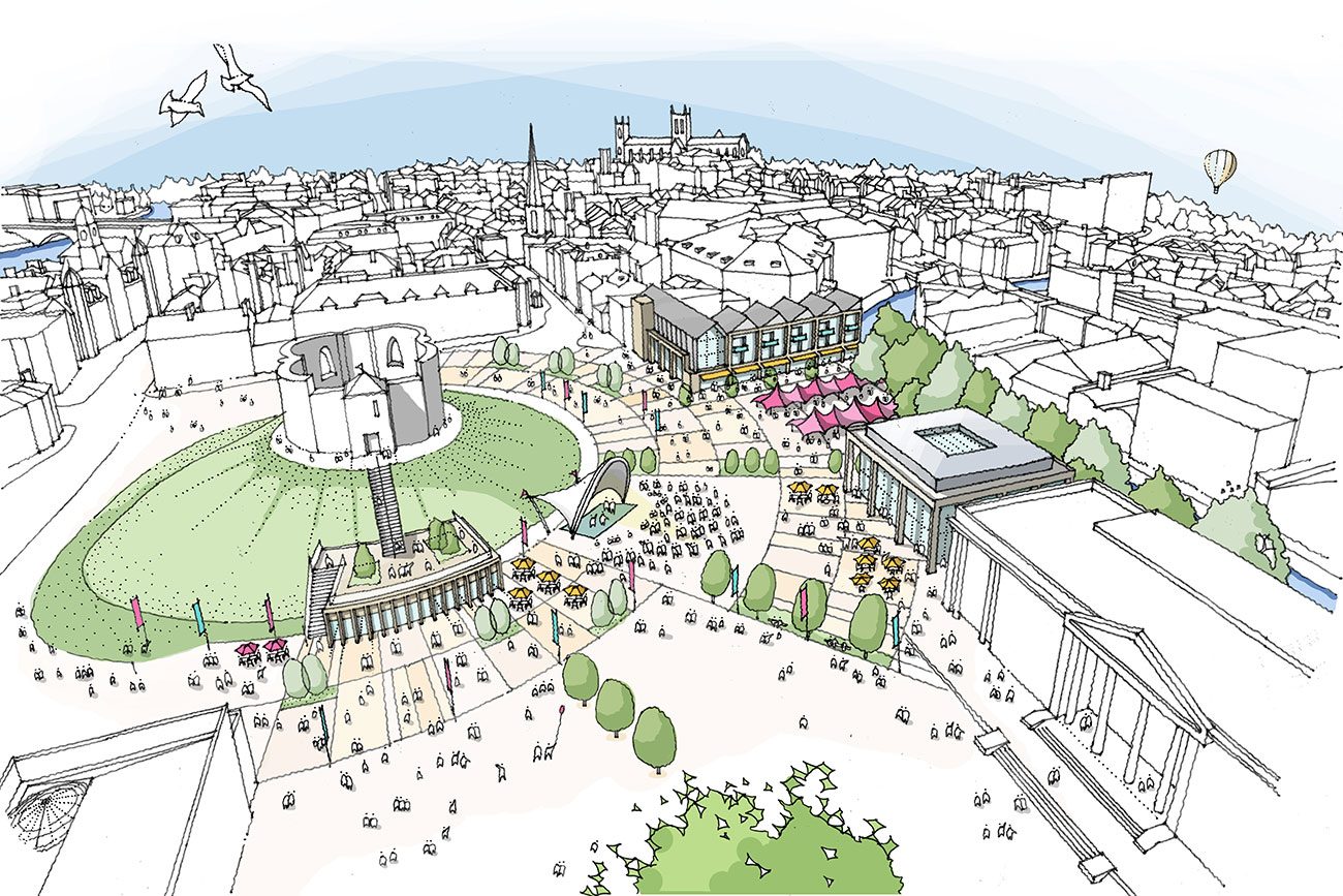
Castle and the Eye of York

The vision for this area is to replace Castle Car Park with a new public space for people to sit, relax, eat, drink and enjoy events.
Taking in the whole of the Eye of York and wrapping around Clifford’s Tower, the space would frame and tell the history of the site, and open up views of the River Foss.
There would be a ‘new high quality building’ on the rear of the Coppergate Centre, covering Fenwick’s servicing yard.
This would provide restaurants at ground floor level with apartments above.
A new entrance hall and potential new extension to the Castle Museum and would offer new exhibition space, if the museum is successful with its amibitions and Heritage Lottery Funding bids.
St George’s Field

This would become the new ‘arrival point’ for the city with a multi-storey car park and coach parking. It could also feature centre and roof top viewing platform.
The car park would have raised access meaning that, upper floors could be used during flooding.
Junction improvements on part of the inner ring road would allow a right turn in to the car park for visitors from the west of the city, and a right turn out for those leaving to the south and the east. The junction would also feature pedestrian and cycle crossing facilities, creating a new, safe route in to the city.
The car park would be a narrow building to keep the views of Clifford’s Tower and the city when looking from New Walk and along Tower Street.
The area surrounding the car park would become green spaces and a dedicated cycle route to the new crossing.
Foss Basin

The Foss Basin would be brought to life with new homes overlooking the basin, water based leisure activities, and a riverside walkway from the south.
The apartments would be built on the flood wall with a raised access above flood levels, and retain the Environment Agency’s access road to the Foss Barrier.
A waterside building would offer water based leisure activities (such as boats and canoes), realising the potential of the area as place to be enjoyed.
From the south a riverside walkway would create a new route in to town, with bridges over the Castle Mills lock leading up to the new pedestrian and cycle crossing.
As the pathway is too narrow for both people and bikes, a new dedicated cycle route to the crossing, would be created through St George’s Field.
How will it be funded?
The estimated total costs of the project is £30m.
The potential gross surplus income from the council owned residential and commercial development opportunities is £22.5m.
The council hopes to fill the gap of £7.5m through a bid to the West Yorkshire Transport Fund.
What’s the timetable?
The work would be split into four packages.
Planning permission for Work package 1 – the multi-storey car park on St George’s Field and apartments on the former Castle Mills car park – would be sought in autumn 2018.
Work would start in spring 2019, with the car park completed in autumn 2020.
Work package 2 – including the redevelopment of Castle Car Park to create new public realm, the riverside walkway at the rear of the Castle Museum, and the new Foss Bridge – would take place in 2020-21.
The whole redevelopment would take five to ten years to complete.
Riverside Walk

A riverside walkway would be created north of Castle Mills bridge, by opening up the rear of the Castle Museum to 24/7 public access.
A new park area would link to a pedestrian cycle bridge over the River Foss. The semi-circular design would provide a route around the narrow section at the rear corner of the museum, and link through to Piccadilly.
The bridge would land on the council-owned Castle Mills site, meaning delivering this part of the proposals is in the city’s control, and that of York Museums Trust.
The rest of the Castle Mills site would be turned in to a new apartment building, with commercial uses at ground floor level, as part of the vision to turn Piccadilly into a vibrant city-living neighbourhood.
Piccadilly

The idea is to transform Piccadilly into a vibrant neighbourhood, based around a pedestrian friendly street – a hub for independent traders with apartments above.
A new southern junction will allow traffic to turn right into Piccadilly across the gyratory.
Once the Spark:York tenancy ends in June 2020, 17-21 Piccadilly would become a permanent development of small commercial units at ground floor level with apartments above.
Castle Mills car park would also provide ground floor commercial space, new apartments and a pedestrian cycle bridge over the River Foss to the new public spaces beyond.
The council doesn’t own the other sites on Piccadilly (Banana Warehouse, 46 Piccadillly and Ryedale House).
It plans to work with developers to invest in reducing the width of the road, improving the look of the street and bringing derelict sites back into use.
What they said
 I’m delighted to reveal a masterplan which is both deliverable while meeting residents’ ambitions and respecting the area’s heritage.
At its heart is one of our most historic sites which, for the first time in decades, will have the car-free setting it deserves.
The high quality public space around it will set the tone for the total transformation of this part of York.
– Ian Gillies, council leader
The Castle Gateway sees of our most loved heritage side-by-side with some of the city centre’s most awkward and under-used spaces.
Thanks to an open conversation with residents, we have a plan which breathes new life into all of it. We have a shared vision which has extensive support. Today we’re committing to deliver it.
– Andrew Waller, deputy leader
 The Castle Gateway masterplan is the product of a serious and long term open conversation.
The masterplan is not the end of the engagement. The masterplan offers us a future in outline – there will be lots of opportunities for anyone interested to get involved and to work together to develop the detail.
– Helen Graham, My Future York
Two other bodies were involved alongside the council. My Future York hosted a nine month consultation into what to do with the area.
And the Castle Gateway Advisory Group, made up of the principal landowners, has challenged the emerging proposals to make sure they meet high standards in areas like heritage, conservation and urban design.
The masterplan and delivery timetable will be considered at the council’s Executive on Thursday 26 April. You can read the full council report here