Temperatures of 40°C have been forecast in the UK and the Met Office has issued the first ever Red warning for exceptional heat.
York, Selby, Tadcaster and other parts of North Yorkshire are in the area covered.
That means temperatures likely in the high 30s today (Monday) and tomorrow and in some places perhaps even reaching 40°C, especially further south down the A1.
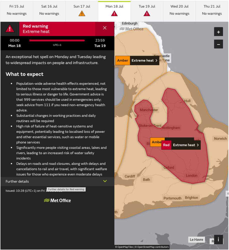
The Red Extreme heat national severe weather warning will cover Midnight Monday to the end of Tuesday (18th and 19th July) for parts of central, northern, eastern and southeastern England.
An Amber Extreme heat warning is in place for much of England and Wales for Monday and Tuesday too.
The amber areas were also being extended to cover Cornwall, west Wales and parts of southern Scotland.
Met Office Chief Meteorologist Paul Gundersen, said “Exceptional, perhaps record-breaking temperatures are likely quite widely across the red warning area on Monday, and focussed a little more east and north on Tuesday.
“We could see temperatures top 40°C and there is an 80% chance we will see a new maximum temperature reached.
“Nights are also likely to be exceptionally warm, especially in urban areas. This is likely to lead to widespread impacts on people and infrastructure.
“Therefore, it is important people plan for the heat and consider changing their routines. This level of heat can have adverse health effects.”
The high pressure near the southern half of the UK, which has been responsible for the warm weather, continues to dominate bringing largely dry and clear weather for most.
[tptn_list limit=3 daily=1 hour_range=1]
Will we get record-breaking heat?
This is the first time we (Met Office) have forecast 40°C in the UK. The current record high temperature in the UK is 38.7°C, which was reached at Cambridge Botanic Garden on 25 July in 2019.
Weather forecast models are run numerous times to help us quantify the likelihood of a particular event occurring and estimate the uncertainty which is always present in weather forecasting to some degree.
What happens after Tuesday
Temperatures are expected to start to return closer to normal for the time of year from the middle of next week onwards as cooler air pushes across the country from the west.
Is this due to climate change?
“We hoped we wouldn’t get to this situation but for the first time ever we are forecasting greater than 40°C in the UK. “ Climate attribution scientist at the Met Office, Dr Nikos Christidis, said “In a recent study we found that the likelihood of extremely hot days in the UK has been increasing and will continue to do so during the course of the century, with the most extreme temperatures expected to be observed in the southeast of England.
“Climate change has already influenced the likelihood of temperature extremes in the UK. The chances of seeing 40°C days in the UK could be as much as 10 times more likely in the current climate than under a natural climate unaffected by human influence.
“The likelihood of exceeding 40°C anywhere in the UK in a given year has also been rapidly increasing, and, even with current pledges on emissions reductions, such extremes could be taking place every 15 years in the climate of 2100.”
A recent Met Office study found that summers which see days above 40°C somewhere in the UK have a return time of 100-300 years at present, even with current pledges on emissions reductions this can decrease to 15 years by 2100.
Whilst a 1°C background temperature increase may not seem significant, the resulting increase in the severity of extreme heat events is already evident in the observed record.
This has widespread and significant impacts.
Advice
A Level 4 UK Health Security Agency Heat Health Alert has been issued for Monday and Tuesday.
This is a level of alert is used when a heatwave is so severe and/or prolonged that its effects extend outside the health and social care system. At this level, illness may occur among the fit and healthy, and not just in high-risk groups.
Government advice is that 999 services should be used in emergencies only; seek advice from 111 if you need non-emergency health advice.
Top ways to stay safe when the heat arrives are to:
- Look out for those who may struggle to keep themselves cool and hydrated. Older people, those with underlying conditions and those who live alone are particularly at risk.
- If you live alone, ask a relative or friend to phone to check that you are not having difficulties during periods of extreme heat.
- Stay cool indoors: Close curtains on rooms that face the sun to keep indoor spaces cooler and remember it may be cooler outdoors than indoors.
- If going outdoors, use cool spaces considerately.
- Drink plenty of fluids and avoid excess alcohol.
- Never leave anyone in a closed, parked vehicle, especially infants, young children or animals.
- Try to keep out of the sun between 11am to 3pm, when the UV rays are strongest.
- Walk in the shade, apply sunscreen and wear a wide-brimmed hat, if you have to go out in the heat.
- Avoid physical exertion in the hottest parts of the day.
- Make sure you take water with you, if you are travelling.
- Check the latest weather forecast and temperature warnings – you can find these on TV, YorkMix Radio after each news bulletin, mobile app or website.
- During warm weather going for a swim can provide much welcomed relief. If you are going into open water to cool down, take care and follow local safety advice.