The Environment Agency is investing £21 million of taxpayers cash to improve flood defences in the Clifton and Rawcliffe area.
This will provide a high standard of protection against future flooding, benefitting 135 homes and protecting local businesses as well. It will also reduce the risk of flood water affecting Shipton Road, keeping an important transport route into the city open.
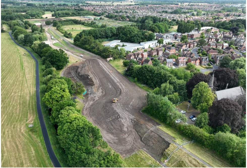
In spite of delays resulting from flooding in February this year, the second phase of construction started on schedule in April and contractors have since made good progress, aided by the dry weather.
They have been working on the middle section of the existing embankment, starting from the allotments end of Rawcliffe Meadows and progressing through the meadow towards the Tansy Pond.
Along part of this route the old embankment has been removed and in other locations they’ve been able to keep the original structure and raise the height of it.
[tptn_list limit=3 daily=1 hour_range=1]
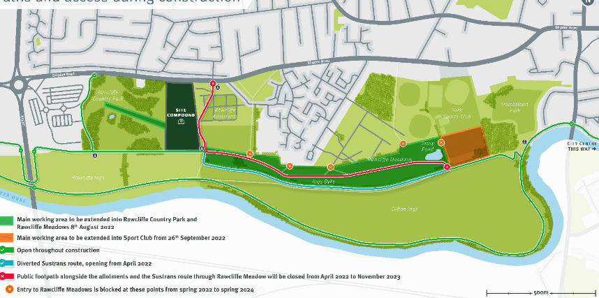
Path closures in Rawcliffe Country Park
From 8th August, work will begin on the extension of the embankment into Rawcliffe Country Park, as shown in the map ; the green ‘arm’ extending into the park from the site compound.
The Environment Agency says: “This means we will need to fence off a large working area for approximately ten to twelve weeks whilst building the new embankment.
“This area will then remain closed off until summer next year to allow the newly seeded grass cover to establish over the winter.
“Although there are no public footpaths in this area, several of the more informal paths will need to be closed whilst heavy machinery is working there.
“Once the construction phase is over, we will aim to reopen one of the paths running next to the cornfield in the autumn, to provide a circular walking route for visitors using the park.
“In summary the park will still be open for visitors, with land on either side of our working area still accessible. However, some areas will remain inaccessible until the summer of next year
“We recognise that these path and entrance closures will make it more difficult for people to gain access to the Ings over the next two years and apologise if this causes inconvenience or
frustration.
“Some of the shorter circular routes for walking or cycling accessed from entrances
onto the middle section of the Ings will no longer be usable.
“However, these restrictions are absolutely necessary so that we can complete essential flood defence work without putting the public at risk. “
If you have any questions about these changes, you can contact us by email at this address:
[email protected].
You can also find maps showing these access changes on notice boards at several locations on the Ings or you can access the Clifton Ings page of the York Flood Alleviation Scheme website: https://consult.environment-agency.gov.uk/yorkshire/yorkfas/